Planning a sea kayak or paddleboard outing: route, tide, wind
At sea, the outing is decided before you launch: where the wind is coming from, when the tide turns, where you get in and where you can take shelter. Here is how to prepare it all from the map.
Three questions to settle before you launch
Where is the wind coming from? Its strength matters, but its direction matters more. A wind blowing from the land out to sea looks calm at the shore: the water is smooth in the lee of the coast. Yet it pushes you out to sea, and every paddle stroke back is against it. It is the classic trap for kayakers and paddleboarders.
What is the tide doing? Its timing decides the current in channels and narrows, and how much water is left in front of the slipway. At low tide, some beaches turn into hundreds of metres of mud or rocks to cross with the boat on your shoulder.
Where to launch, where to land? A slipway with a car park nearby, and along the route, places where you can land if the weather turns. Five kilometres of cliffs are not paddled like a bay lined with beaches.
Drawing the route along the coast
Ordinary routing can't go out to sea: there are no paths. Instead, GPX Edit Pro builds a track that follows the coastline, at the distance you choose.
- Open the route windowDraw → Via routing, then the 🛶 Waterway profile.
- Place the start and the finishTwo points near the shore: the launch slipway, and the goal of the outing (a headland, a beach, the next harbour).
- Choose the distance from the shore150 m to hug the coast, 300 m for a more direct line, less exposed to the backwash off the rocks.
- Follow the coastThe track appears with its distance and an estimated duration (5.5 km/h by kayak, 3 km/h by paddleboard, at Medium pace). Save it.
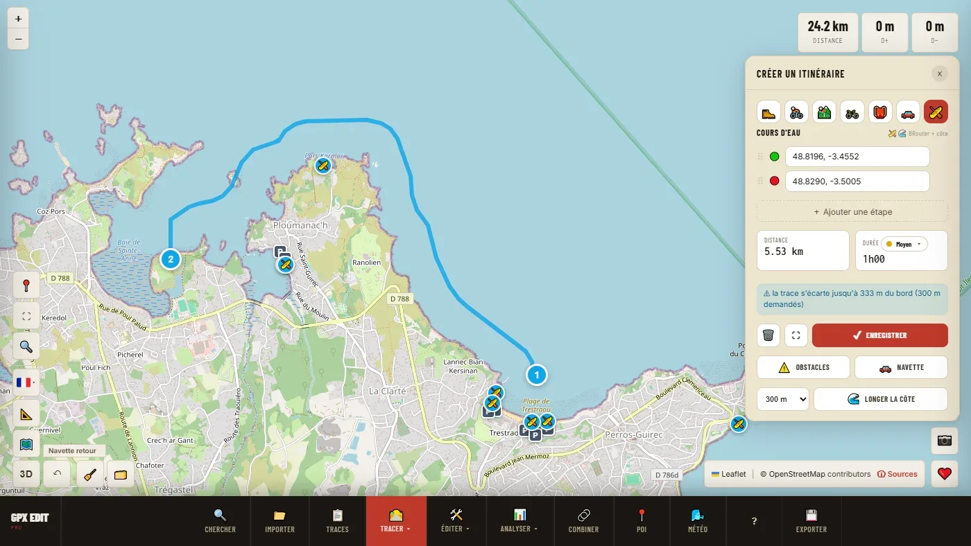
The banner only speaks up if there is something to report: the track cuts across a cove and strays further than requested, or passes closer to the shore in places. The tool doesn't go into every inlet, otherwise the track would become lacework that nobody would paddle. For a long outing, split it into two or three sections.
Choosing your slipway
Zoom in on the area: mapped slipways, ramps and landing stages appear, with the nearest car park. A start point placed next to one snaps to it, and the window tells you so. A point placed far from any slipway is flagged as a "free point": nothing stops you from setting off from a beach, but check on site that access is possible and allowed.
Reading the wind: the dot that matters
Open the weather map (Weather button in the toolbar) and click your slipway. The forecast for that point appears hour by hour, in daylight, over 7 days.
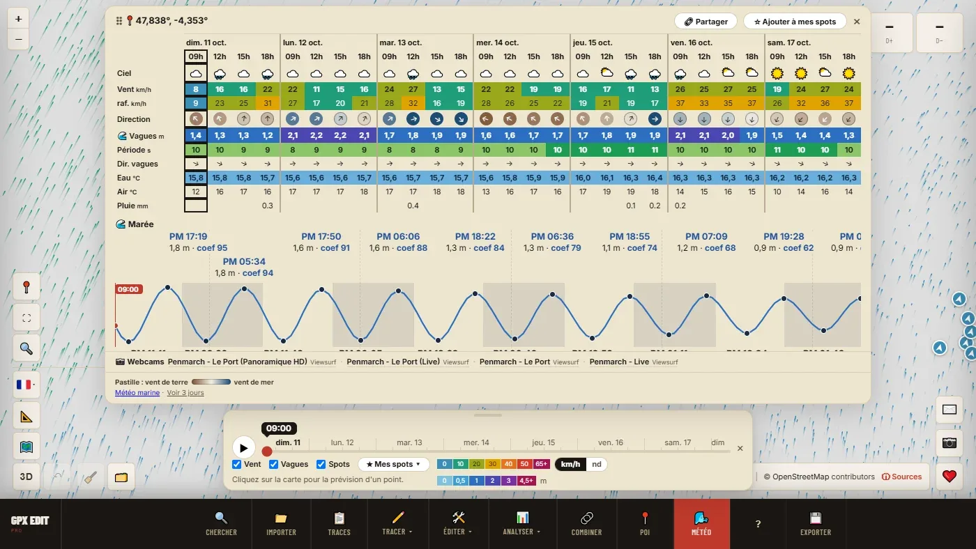
- Wind and gusts: in a sea kayak, above 20 km/h you start to struggle; on a paddleboard, from 15 km/h. A big gap between the mean wind and the gusts means the wind is irregular.
- The dot around the direction arrow: brown when the wind comes from the land, blue when it comes from the sea, in between when it blows along the coast. It is worked out from the water the wind crosses before reaching the point, not from the orientation of the beach.
- Waves and period: below 8 seconds, a short, choppy sea, tiring even with small waves.
- Water: the sea temperature, to choose between shorts and a wetsuit.
A brown dot over the hours of your outing is a serious reason to change your plans: if you get tired, capsize or lose your paddle, the wind carries you away from the shore.
Tide and coefficient
Below the forecast, the tide curve gives the high waters (HW) and low waters (LW), their heights and the coefficient of each high water. For the tide alone, without opening the weather map: right-click on the map within 10 km of the coast (long press on a phone), then Tide here.
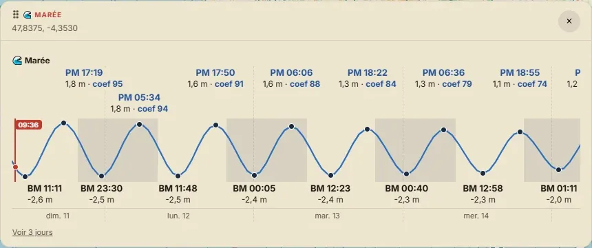
The higher the coefficient, the stronger the currents in channels, narrows and around headlands. A simple rule: plan the outing so the current is with you on the way back, when tiredness sets in. The coefficient is only given on Europe's Atlantic coast, including the Channel and the North Sea.
Letting the tool find the window
Save the spot (☆ Add to my spots), then ⚙ My conditions. The Sea kayaking preset starts from: wind from 0 to 20 km/h, gusts up to 30, no offshore wind, waves of 1 m at most, visibility of at least 2 km, no thunderstorm, a window of at least 3 h. The Paddleboarding preset is stricter: wind up to 15 km/h, gusts up to 25, waves of 0.5 m at most.
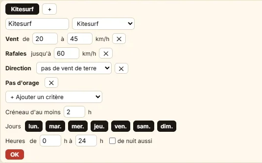
Add what matters for your stretch of water: Tide: around high tide for a bay that dries out, Water from 16 °C, or specific days and hours. The forecast gains a row ticked ✓ at the right hours, and ★ My spots shows the next window over 7 days. If there isn't one, the list says what is blocking it: "nothing in 7 days (wind)".
Before you set off
- Export the track to GPX for your watch or your phone.
- Send the share link to someone who stays ashore, with your planned return time.
- Look at the nearby webcams (📷 Webcams row under the forecast) and the official marine forecast.
GPX Edit Pro does not replace the marine forecast, the official tide tables (the SHOM in France) or a look at the water. If conditions on site don't match the forecast, the sea is right.
📖 Step by step in the manual: Follow the coast · Slipways · The spot forecast · Tide here · My conditions
Plan your next outing on the water.
Open the editor for free →